


|

|

|
Owing to the financial support of the SNSF the first digital geological map in Kyrgyzstan had been created by 2004 (SNSF Project No 7KSPJ065518). Scientific community and representatives of institutions of governing in Kyrgyzstan were informed about results of the project in the presentation, which was held in a conference-hall of the Pinara Hotel on June 28, 2004. A short video of the presentation is presented in the web-site (view). The result of the SCOPES Program 2005-2008 is a prolongation of these labours (SNSF Project No IB7320-110694).
The Orographic Scheme shown below is intended to help finding one's way in the region (Fig. 3.1).
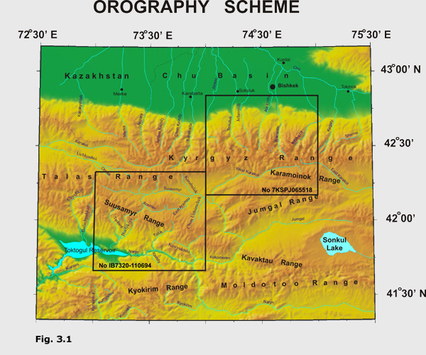
The prominent orographic unit of the Project 7КSPJ065518 area is the Kyrgyz Range trending on 455 km nearly EW at the maximal width of 40 km. At the Bishkek City meridian the range reaches altitudes of 4600-4900 m. The Chu Foreland Basin filled by up to 4-5 km thick Cenozoic deposits occur on the northern site of the Kyrgyz Range. On the southern site of the Kyrgyz Range, the Suusamyr intermontane Basin is replaced eastward by the Djumgal and Karamoynok Ranges. The drainage network of the northern slope unites rivers belonging to the Balkhash Basin. Most streams flowing from the southern slope of the Kyrgyz Range, the Djumgal and the Karamoynok Ranges belong to the Syrdaria River basin flowing throughout the Fergana Basin.
IB7320-110694 project area is located to the southwest. The main orographic unit in its north part is the latitudinal Talas Range of 260 km long, 40 km wide and with tops of 4165 - 4482 m high. Suusamyr Range is the second large orographic unit; it is 126 km long, its maximal width is 31 km, separate tops achieve altitudes of 4048 m. Suusamyr intermontane basin with absolute bottom altitudes of 2000-3200 m, the basin is 150 km long, maximal width reaches 24 km. Cenozoic sediment thickness varies from 1050 m to 1950 m. Ketmentyube intermontane basin is the southern border of Suusamyr ridge. It is 50 km long, maximal width is 22 km and the bottom absolute altitude varies within 800-1500 m. Cenozoic sediment thickness varies within 600-2600 m. Hydrographic network of the given area belongs completely to the Syrdaria River basin which flows into the Aral Sea (Lake).